This is the submission of the Campaign for Better Transport on Ara Tuhono: Puhoi to Warkworth project to the Environmental Protection Agency. A pdf version of the submission is here .
Introduction
The Campaign for Better Transport (CBT) is a non-politically aligned group that advocates for sustainable transport policies and projects throughout Auckland and the rest of New Zealand. The CBT regularly advocates for better alignment between land-use planning and its effects on the transport network, better public transport and better walking and cycling facilities.
Summary of Submission
The CBT generally opposes the Puhoi to Warkworth section of Ara Tuhono (“the Project”). This is for a number of reasons that are detailed further in this submission.
- There is a high probability the project will not realise the project objectives and benefits sought by the NZTA
- The justification for the Project on the grounds of route security is based on a very low number of incidents on the existing SH1
- Safety issues on the existing SH1 should be addressed. Should the Project be confirmed, traffic volumes on the existing SH1 will be similar to present day levels. Users of the existing SH1 in 2026 are three to four times more likely to be involved in injury accidents than users of the Project route
- Likely traffic volumes for the Project have been overstated. The Transportation and Traffic Assessment Report lacks the necessary detail required to conclude support for the Project
- Reports to back up claimed economic benefits are not based on any empirical data or studies
- Alternative options which will achieve NZTA’s objectives have been not been considered
Legal Framework
Section 171(1) of the Resource Management Act outlines the process by which a notice of requirement is considered by a territorial authority (or the BOI in this case). A variety of matters must be taken into consideration. Of particular relevance to this application and the CBT’s submission are the following:
- Part 2 5 (2) – enabling people and communities to provide for their social, economic and cultural well-being and for their health and safety
- 171 (1) (b) – whether adequate consideration has been given to alternative sites, routes, or methods of undertaking the work
- 171 (1) (c) – whether the work and designation are reasonably necessary for achieving the objectives of the requiring authority for which the designation is sought
Project Objectives and Benefits May Not Be Met
The AEE summarises the benefits of the project as:
- Improved route security and resilience of the State highway network north of Auckland through reducing the reliance on one main route (the current SH1);
- Improved safety performance compared to the existing SH1 between Puhoi and Warkworth with the indicative alignment designed to RoNS standards;
- Reduced travel times and improved travel time reliability along the State highway network north of Auckland increasing accessibility across many parts of the Region’s road network; and
- Potential for economic development as a result of travel time savings, improved trip time reliability and improved inter-regional accessibility between Auckland and Northland.
The following sections discuss each of these claimed benefits.
Improved Route Security
From p.45 of the Transportation and Traffic Assessment Report:
The existing SH1 route is currently closed a number of times a year as a result of events such as crashes, flooding or slips blocking the road. By way of an example, information provided by the NZTA’s network contractor indicates that in the 10 years from 2003 – 2012, SH1 between Puhoi and Warkworth was closed for a total of approximately 64 hours due to 21 crashes.
So, on average, the existing SH1 has been closed twice a year due to accidents for three hours at a time.
We submit that this is a very low number of incidents in which to justify building a further alternative route to the existing SH1 and the existing SH16. The risk of closure should be mitigated not by building an alternative route, but by addressing safety issues on the existing SH1.
Improved Safety
The Transportation and Traffic Assessment Report contains the following table in relation to serious crashes on the existing SH 1.
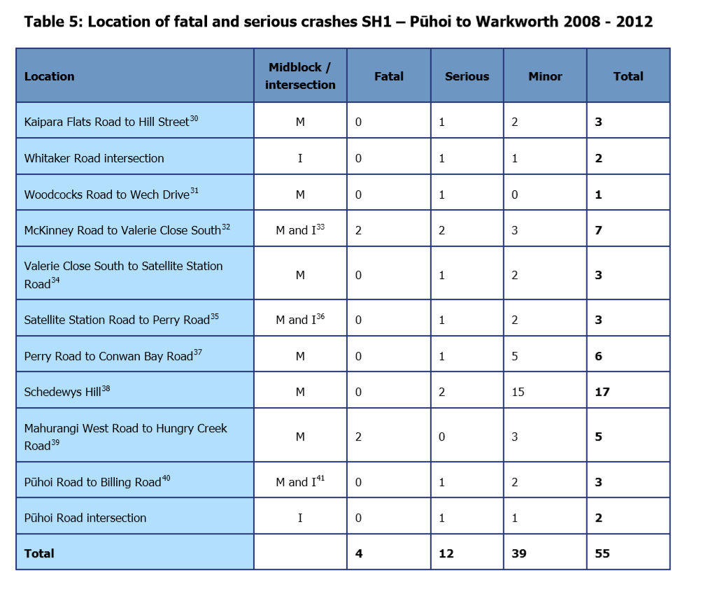
It is obvious that there are a number of “black spots” on the existing SH1 route, however the Project will not address these areas despite the statistics providing a compelling reason to do so.
From p.45 of the Transportation and Traffic Assessment Report:
The average annual number of injury crashes in the corridor is forecast to decrease by five (23%) in the year 2026 in comparison to the future traffic volumes on the existing SH1 route.
We assume that the traffic modelling has produced this result because traffic volumes on the existing SH1 will be similar to the volumes experienced today. Consequently accident rates can be expected to be unchanged on the existing SH1.
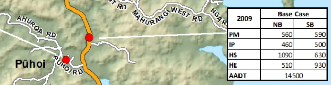
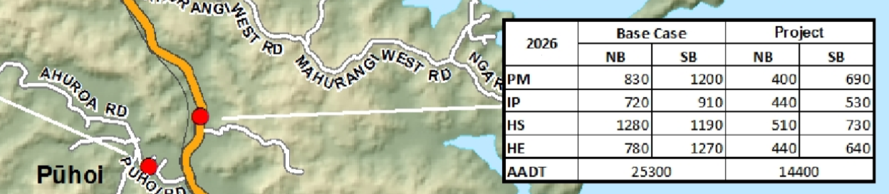
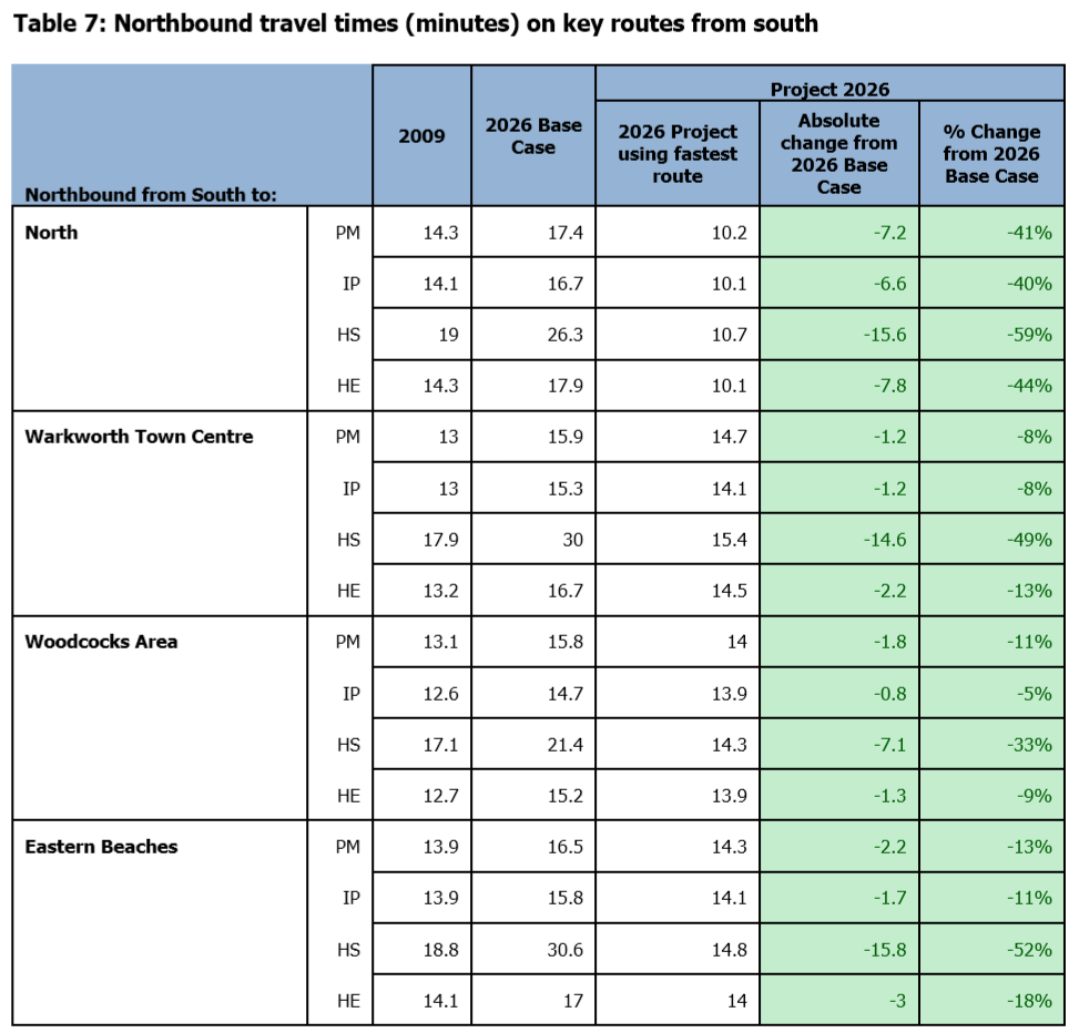
The unchanged traffic volumes are borne out in the following two snapshots taken from the Transportation and Traffic Assessment Report, showing traffic volumes at Hungry Creek Road will be similar to 2009 levels, disregarding the infrequent Holiday Start (HS) and Holiday End (HE) periods.
We submit that the modelled figures for reductions in injury crashes are an unacceptably low de facto target for the Project. Should the Project be confirmed, we submit that safety improvements to the following black spots are necessary to mitigate unnecessary injuries and loss of life:
- McKinney Road To Valerie Close South
- Perry Road to Conwan Bay Road
- Schedewys Hill
- Mahurangi West Road to Hungry Creek Road
We also note that there is a social equity issue in that motorists who cannot pay the toll, or cannot use the Project route because the Project does not serve their destination efficiently (for instance Puhoi – South Warkworth), will be subject to a substantially more dangerous road than the Project route. This is shown by the following chart taken from the Transportation and Traffic Assessment Report, which demonstrates that users of the existing SH1 in 2026 are three to four times more likely to be involved in injury accidents than users of the Project route.

It is conceivable that a higher toll will be introduced for trips between Puhoi and the northern point of the Project. For instance, the existing NGTR toll could be increased, or an additional tolling gantry could be installed north of Puhoi so that users of the Project route are charged an additional fee.
Should this occur, then the social inequity will be more pronounced as more motorists will elect to take the free existing SH1 option rather than pay the toll, taking the risk of driving on a relatively unsafe road.
Projected Traffic Volumes
From p.13 of the AEE:
If no capacity improvements are provided on the State highway network between Puhoi and Warkworth, travel times in the corridor as a whole are forecast to increase significantly as traffic volumes on SH1 increase in the future. Traffic volumes on the existing section of SH1 between Puhoi and Warkworth are anticipated to grow by approximately 4% per annum to the year 2026 and be in the order of approximately 25,000vpd
We submit that the projected traffic volumes have been overstated in order to support the Project. From p.14 of the Transportation and Traffic Assessment Report:
Drivers generally only use SH16 as an alternative to SH1 during holiday periods when SH1 becomes heavily congested. This congestion will be largely eliminated by the Project. With the Project in place, many of the long distance trips will actually take place in the SH1 / Project corridor rather than SH16. To reflect this, we made some manual adjustments to the model in the Holiday Start and Holiday End periods. 75% of trips that used SH16 but did not have a destination along SH16 (and were travelling further north to Wellsford) were forced to enter the model network on SH1 at the southern extent of the model rather than using SH16.
We submit there is no valid reason for assuming 75% of SH16 users (many of whom presumably reside in West Auckland) will use the Project route during holiday periods. This is because congestion will not be largely eliminated by the Project during holiday periods.
The following chart from p.55 of the Transportation and Traffic Assessment report identifies congestion will occur on the existing SH1 between Warkworth and Wellsford.
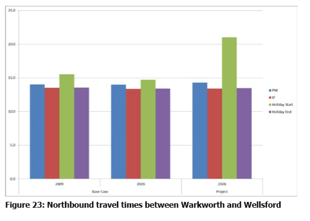
We assume that this is because at the northern interchange where the existing SH1 and the Project routes merge, congestion will occur as three lanes merge into one.
Knowing that congestion will continue to occur during holiday periods once the Project route is completed, making a manual adjustment to the model so that 75% of existing SH16 users are forced into the Project model needs to be further justified.
It is worth noting that the Transportation and Traffic Assessment Report dismisses the increased travel times during the holiday period, stating:
This is a minor adverse effect for relatively few holiday periods each year.
Yet a considerable amount of modelling contained within the report, and hence justification for the project, is based around trips within the “holiday start” and “holiday end” periods.
Since the report acknowledges the holiday periods only occur a few times a year, we submit that inclusion of holiday peak travel figures in the Transportation and Traffic Assessment Report are irrelevant and should not be part of any justification for the project.
Because of the obvious shortcomings of the Transportation and Traffic Assesment Report, we submit that the Board of Inquiry should commission its own review of the report. There is a precedent for this with the BOI for the Basin Reserve flyover project in Wellington commissioning a similar review of the NZTA commissioned traffic assessment report.
Unless NZTA can guarantee that there will be no extra toll levied, any peer review of the Transportation and Traffic Assessment Report should also test scenarios of an additional toll being charged for trips between Puhoi and Warkworth. The imposition of an additional toll would cause considerable diversion of traffic to the existing SH1,and thus have a material affect on expected traffic flows.
Reduced Travel Times
From p.60 of the Transportation and Traffic Assessment Report:
Ignoring the relatively few holiday periods each year, we submit that the Project is not justifiable on the grounds of reduced travel times.
Predicted travel times appear to be exaggerated. The Project route measures 18.5 km in length. The fastest travel time of 10.1 minutes for inter-peak travel equates to an average speed of 109.9 kph, or 10 kph above the legal speed limit. While NZTA have indicated that the Project route will have a design speed of 110 kph, there is no indication that the law will be changed to allow these speeds for cars and trucks.
(In any case, allowing higher speeds of up to 110 kph negates claims of operating cost savings, as fuel consumption is dispropotionately higher at higher speeds.)
We submit that a more realistic assumption of the average speed of trucks and vehicles should be made to determine predicted travel times. This information should be readily available from the nearby NGTR, which is of a similar standard to the Project.
Without the Project, travel times from South to North are expected to increase by only 2.6 minutes inter-peak and 3.1 minutes during the pm peak. We submit that these increases do not warrant and intervention of the scale of the Project.
We note that travel time savings with the Project for journeys other than South to North are substantially smaller – less than 3 minutes at best, ignoring holiday periods. We assume that his is because the “fastest route” for these projects is in fact the existing SH1 road.
We submit that the NZTA should conduct further assessment work focussing on improvements that can be made to the existing SH1 to achieve travel time savings for all motorists travelling between Puhoi and Warkworth, not just the proportion of traffic able to use the Project route.
Travel Time Reliability
We note from the Transportation and Traffic Assessment Report that currently 66% of all trips between Puhoi and Warkworth vary by only +/- 1.4 minutes. 95% of all journeys north are between 12.2 and 17.8 minutes. We submit that the Project cannot be justified on the basis of improving travel time variability, given the variability is already extremely low in terms of absolute minutes.
Projected variability in the 2026 base case scenario is also questionable, given that traffic volumes are unlikely to grow by the amounts claimed for reasons already stated.
From the p.13 of the AEE:
Congestion resulting in increased travel times and reduced travel time reliability is already a problem along the SH1 corridor north of Auckland, particularly at Warkworth where congestion regularly occurs during weekday evening commuter peak periods. More severe congestion is experienced when incidents such as crashes or slips occur, or during weekends or holiday periods, the latter due to an increase in both long distance through trips and local traffic travelling within and through Warkworth resulting in in higher traffic volumes. If no capacity improvements are provided on the State highway network between Puhoi and Warkworth, travel times in the corridor as a whole are forecast to increase significantly as traffic volumes on SH1 increase in the future.
We note that a bypass of Warkworth is already planned (the Warkworth Western Collector route). We submit that travel time reliability will be improved, particularly in and around Warkworth, with the addition of this route.
For freight movements, we note that less than half of all HCV movements in the Puhoi to Warkworth corridor will use the Project route, as shown in the figure taken from p. 68 of the Transportation and Traffic Assessment Report.
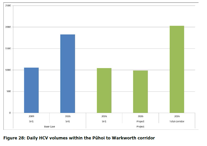
This being the case, we question the value of the Project to the freight industry, and again submit that NZTA should conduct further assessment work focussing on improvements that can be made to the existing SH1 to achieve travel time savings for all freight movements in the corridor, not just those movements on the Project route.
Claimed Economic Benefits
The AEE Executive Summary provides the following chart:
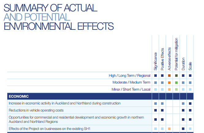
The sole basis for this summary appears to be Appendix C of the AEE – Letter from M Copeland. This document contains generalised economic assertions but little in the way of empirical evidence.
Increase in economic activity in Auckland and Northland during construction
The letter does not explain by how much economic activity will increase, or exactly how Northland’s economy will benefit. Assuming “Northland” is meant to be the area encompassed by the Northland Regional Council, then the boundary for this lies some distance north of Wellsford.
It is difficult to see how this translates into the summary assessment shown.
No mention is made either of the current skill shortage in the construction sector. This will mean construction costs for the Project could be significantly higher as a premium will have to be paid to attract suitably qualified workers.
Reductions in vehicle operating costs
For many users travel time savings are likely to be less than three minutes and furthermore less than half of all truck movements will be using the Project route.
It is also foreseeable that an additional toll could be levied on users of the Project route, which would add significantly to vehicle operation costs, yet this is not mentioned in the letter.
For these reasons we submit that classifying reductions in vehicle operating costs as highly significant and positive is overstating the case.
Opportunties for economic growth in northen Auckland and Northland Regions
Since 1984, the Northen motorway has been extended by 30 km to from Sunset Road to Puhoi. No analysis has been supplied by NZTA on whether this led to significant economic growth in Northland.
There is no evidence supplied that the 18.5 km Project will bring opportunities for growth in Northland, in comparison with spending on other alternatives.
Summary
In summary the economic assessment appears to be high level, generic and could in fact be applied to any NZTA project. As the letter points out, if funds are not utilised for the Project, then other projects are likely to be funded instead.
Given the scale of the Project, the potential for the misallocation of capital is large. We submit that a far more rigourous, independently reviewed economic assessement should be supplied by the NZTA in support of their application.
Consideration of Alternatives
NZTA have considered a number of roading options in their applicaiton, but all involve the construction of a four lane expressway or motorway. No evidence is given as to why this configuration is necessary, especially given the relatively low traffic volumes on the route when compared with other roads around New Zealand.
Indeed, the road between Warkworth and Wellsford will remain a single lane highway for the foreseeable future, so there is a strong argument that this project will simply move the bottleneck to the northern interchange for longer distance trips.
Potentially a far more cost effective solution, which will provide benefits to all users of the Puhoi to Warkworth corridor, could be achieved by simply fixing the “pinch points” of the current SH1. In particular:
- A by-pass of Warkworth township (already in scope in the Base Case)
- Schedewys Hill
- Pohuehue Viaduct
- Hill St intersection / Matakana turn-off
We submit that this alternative be costed and analysed as part of NZTA’s application.
We also note that upgrading the existing rail line does not feature in the study of alternatives. This is mentioned on p.14 of Justification for the Project:
The volumes moved by rail and coastal shipping being small at 3% and 11% respectively, and these are unlikely to increase significantly in the future…
Movement of freight north of Auckland by rail is constrained by the low standard system of the North Auckland Line (NAL). Rail lines north of Auckland must operate at low speed due to theconfiguration of the existing infrastructure, thus reducing the efficiency of transporting goods interregionally via rail. The proposed Marsden Point branch linking the NAL to Northport may increase the amount of freight transported by rail, though the use of this branch would still be constrained by the existing configuration of the NAL.
The main reason that volumes moved by rail are unlikely to increase in future is only because there no investment planned in the NAL. If investment was planned then it is likely growth would be achieved.
We accept that it is not within the scope of the NZTA to provision rail networks in New Zealand, however we submit that it would be reasonable to include indicative costs and impacts on SH1 traffic volumes if the NAL was upgraded as described, especially given the potential for rail’s lower environmental impacts.
